Robinson Crusoe Island used to be called Mas a Tierra (closer to land). It's an island in an archipelago and is the second largest island of the Juan Fernandez Islands, located about 300 or so miles west of Chile. It's part of Chile. We anchored in Cumberland Bay, next to the small (700 population) town of San Juan Bautista, on the north coast of the island.
The island itself was where a marooned sailor and pirate named Alexander Selkirk called home from 1704-1709. His story is believed to be part of what inspired the novelist Daniel DeFoe's story of Robinson Crusoe. The government of Chile renamed the island to Robinson Crusoe Island to reflect the literary lore associated with the island and to attract tourists (imagine that) in 1966.
It's a pretty important place to scientists, as over 60% of the native plants there are endemic to the island, as are over 200 species of insects. It's also home to the very endangered hummingbird called the Juan Fernandez Firecrown. There's only about 200 left today.
The town derives it's largest amount of income from spiny lobster fishing. The town is very small and was nearly destroyed in a 2010 tsunami. 16 people died and over half of the town was swallowed up in the water flooding. If it were not for a 12 year-old girl seeing the water rushing out and recognizing it as a tsunami, and sounding the alarm, more people would have lost their lives. Today, 9 years later, a good part of the small town has been rebuilt, but there is still much to be done. We've got about 700 passengers on our ship, so our arrival there basically doubled the town's population for one day. Unless you're into hiking up mountains, there's not much else to do there, other than to enjoy the beautiful scenery with a walk along the waterfront and perhaps a quick climb to see the caves that sit just above the town square.
Andrea and I had been told different things in terms of how long the hike up into the park would take. Some said it was 30 minutes up, others said it was 2 hours. We liked the idea of 30 minutes, for obvious reasons. So every time we took a wrong turn and then tried a new route, Andrea would say "Your 30 minutes starts now." It became a bit of a running commentary. Even a couple of the signs along the trail (the right one, once we found it), had conflicting information about how far the end spot was. One sign said 1450 meters, another farther along (your 30 minutes starts here again), said 2000 meters. Eventually, we arrived at our designated spot and were glad of it. Total hiking for the day - 7 miles. Half of it up a mountain..............all in all it took up about 3 1/2 hours including our missteps.
Snort gets a new towel buddy every night.
Up at Plazoleta De Yunque, the "end spot" of our hike, there are some beautiful picnic tables and these tree tables. Isn't that beautiful wood?
This cat hung out with us at the Patriot Caves
Inside the largest of the Caves, there's what appears to be an altar at the back. These caves were inhabited by banished activists from the war for independence with Spain
Here's that cute cat again.
This is a view from about 3/4 of the way up our mountain. That tiny thing in the water out there is our ship.
A cave
View on the trail up the mountain
View of the island from our ship
Spiny lobsters - they were huge! And alive...........
Almost to the top!!!
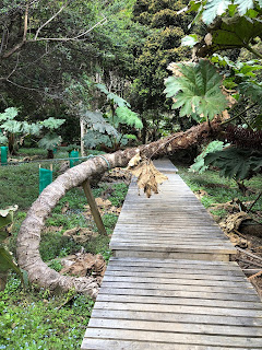
A boardwalk at the Plazoleta del Yunque. We were on the hunt for the elusive hummingbirds.
3/4 of our hiking trail was this. It was tough going up and tougher coming back down. Slippery.
Pretty picnic table and benches
These are cabbage trees. Endemic to the island. They produce big red flowers and the hummingbirds love them.
One of several "wrong" trail signs.
The town from the ship
There's one of those big red flowers.
Old cannons
Travel quote: "Traveling leaves you speechless then turns you into a storyteller" Ibn Battuta
Stay tuned for more Pig Tales!!


I admire your hiking skills and perseverance!
ReplyDelete